Here’s how I use ChatGPT to search Open Street Maps using Overpass Turbo, and then bring it into mapping programs like CalTopo.
🗺 Overpass Turbo: https://overpass-turbo.eu/
👀 LATEST GEAR LIST: https://hikingguy.com/best-hiking-gear/
♥️ SAY THANKS: https://hikingguy.com/support-hiking-guy/
00:00 Maps Have a Problem
00:38 Leveraging ChatGPT
02:56 Exporting Results
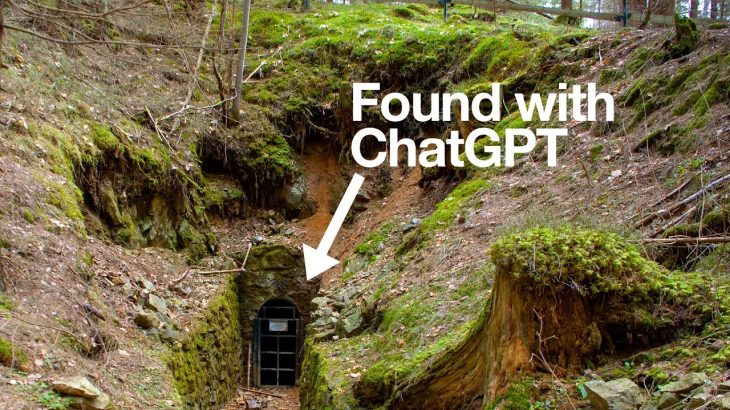
04:05 Abandoned Mines
05:46 Mountains With Trails
06:47 Overcoming Errors
Unlocking the full potential of OpenStreetMap data can be a game-changer for outdoor enthusiasts, map geeks, and explorers. By using tools like ChatGPT in combination with Overpass Turbo, you can easily search for specific geographical features within a given area. For instance, if you’re looking to identify all the natural springs in Angeles National Forest, OpenStreetMap contains all this information in a geolocated database. While manually searching for each spring might be cumbersome, ChatGPT can generate a precise query for Overpass Turbo, enabling you to retrieve all relevant data efficiently.
The process is simple: start by identifying a known location or feature in OpenStreetMap, like Lamel Spring in Angeles National Forest. From there, recognize the tags associated with that feature—such as “natural=spring”—and use ChatGPT to craft a query targeting all instances of that tag within your desired area. By running this query in Overpass Turbo, you can visualize every matching result on the map, vastly improving your ability to explore and utilize this data.
Beyond springs, this method can be applied to any feature tagged in OpenStreetMap, such as abandoned mines in Joshua Tree National Park or even specific hiking trails and peaks. ChatGPT can help refine your queries, allowing you to customize searches to fit your exact needs. Whether you’re planning a hike or conducting more detailed geographical research, combining these tools opens up new possibilities for how you interact with and leverage OpenStreetMap data.
🌎 Bucket List Hikes You Should Try:
https://bit.ly/bucket-list-hikes
👀Subscribe For New Hike & Guide Videos
https://www.youtube.com/@Hikingguy
👍Monthly Email For New Hike Updates:
https://hikingguy.com/newsletter/
🎆Instagram For Insider Hike Info:
https://instagram.com/HikingGuy_com/
#mapping #maps #explore
#hiking #hike #hikingvlog #hikinggear #hikingtrails #hikingandcamping #hikingandcampingforbeginners #hikingandcampingvlog #hikingandbackpacking #52HikeChallenge #backpacking #healthyliving #trails #outdoors #nature